
Dronelab
Most of our drone-based research and monitoring is gathered under the SeaBee project.
 Kasper Hancke
 Medyan Esam Ghareeb
SeaBee: Norwegian Infrastructure for Drone-Based Research and Monitoring SeaBee is a national research infrastructure led and coordinated by NIVA (Norwegian Institute for Water Research), in collaboration with the Norwegian Computing Center (Norsk Regnesentral), NTNU (Norwegian University of Science and Technology), NINA (Norwegian Institute for Nature Research), HI (Institute of Marine Research), and GRID-Arendal. Additionally, industry partners Tiepoint (formerly Andøya Space) and Spectrofly A/S contribute to the project. SeaBee enables data collection using drones, with both aerial, surface, and underwater drones available.
The infrastructure focuses on research, mapping, and monitoring of coastal areas and freshwater systems.
You can find examples of applications and use cases here.
How SeaBee Works:
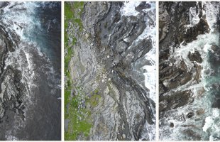
- High-Resolution Drone Imagery: SeaBee utilizes drones equipped with various sensors to collect high-resolution data. Standard image data can provide comprehensive overviews of field areas or offer a bird’s-eye perspective with pixel resolutions down to a few centimetres.
- AI and Verification: The collected image data and other products are used to train AI/ML algorithms for object and nature type identification (e.g., vegetation or individual species). This enhances the efficiency, reproducibility, and cost-effectiveness of coastal zone mapping and monitoring.
- Cloud-Based Sharing: SeaBee has developed a data storage and visualization platform (SeaBee GeoNode) that simplifies handling and sharing relevant data within projects, both internally and externally.
- Sustainability Measures: Accessible information allows effective implementation of sustainable coastal and marine management practices in Norway.
Want to know more about our drone-based research and surveillance?
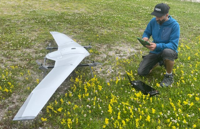
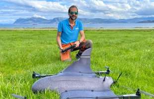
- Fixed-Wing Drones (Long Range):
- DeltaQuad Pro EVOs (2 units)
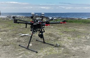
- Rotor Drones (Medium Range):
- DJI MATRICE 300 RTK
- DJI MATRICE 350 RTK
- DJI M600
- Hexadrone Tundra 2
- MavicMini (multiple units)
For a complete overview, visit: SeaBee Equipment
- Sensors for various needs:
- DJI Zenmuse P1 45MP RGB sensor: Standard RGB imaging sensor with high resolution.
- MicaSense Altum 5-band multispectral sensor: Captures infrared and ultraviolet wavelengths in addition to visible light.
- Specim AFX10 hyperspectral sensor: Recognizes specific wavelengths using the electromagnetic spectrum, similar to an optical fingerprint.
- LiDAR (light detection and ranging): Produces digital 3D models of vegetation both underwater and on land, including coastlines.
See the equipment list for a comprehensive overview: SeaBee Equipment
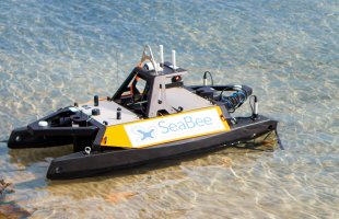
- Remote Surface and Underwater Vehicles:
- Two underwater drones (ROV): Blueye and FIFISH. These underwater drones are used for inspection and visual surveys, including mapping seabed conditions, vegetation, or underwater installations.
- Two remote-controlled surface boats (USV) from Maritime Robotics (Otter): These can be equipped with various sensors and other environmental monitoring equipment. They can operate remotely or follow pre-programmed routes automatically.
Additional Capabilities:
- Ground Truth Data: Precise position data (<2-3 cm) from GNSS base stations, complemented by drone data.
- Georeferenced Orthomosaics (RGB Data): Detailed and accurate overview images, like Google Earth but with much higher resolution. Explore them on the GeoNode.
- DSMs (Digital Surface Models): Represent terrain, topography, and bathymetry, highlighting elevation and underwater features.
- MSI (Multispectral) and HSI (Hyperspectral) Data: Used for habitat classification and object recognition.
- Habitat and Species Mapping: Identifying marine birds and mammals.
- Plastic Identification: Can SeaBee provide data for plastic identification and classification?
For more information on what SeaBee offers and the projects they’ve worked on, visit:
seabee.no
Feel free to reach out if you’d like more information about SeaBee’s services and pricing.


